![]()
![]()
LiDAR
LIDAR is similar to radar technology, which uses radio waves, a form of electromagnetic radiation that is not in the visible spectrum. The range to an object is determined by measuring the time delay between transmission of a pulse and detection of the reflected signal. LIDAR technology has applications in Archaeology, Geography, Geology, Geomorphology, Seismology, remote sensing and many more areas.
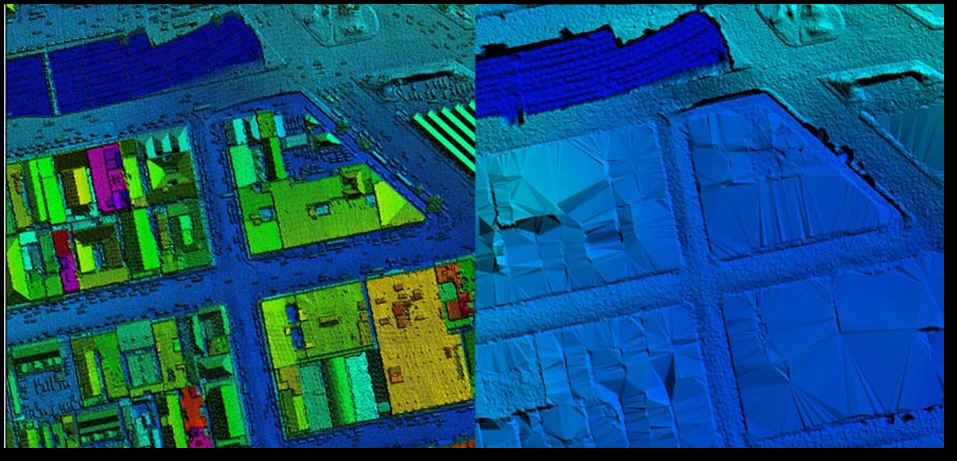
Light detection and ranging (LIDAR), also known as airborne laser scanning (ALS), is an emerging remote sensing technology with promising potential to assisting mapping, monitoring, and assessment of forest resources. Compared to traditional analog or digital passive optical remote sensing, LIDAR offers tangible advantages, including nearly perfect registration of spatially distributed data and the ability to penetrate the vertical profile of a forest canopy and quantify its structure.
A LIDAR system operating from an airborne platform comprises a set of instruments: the laser device; an inertial navigational measurement unit (IMU), which continuously records the aircraft’s attitude vectors (orientation); a high-precision airborne global positioning system (GPS) unit, which records the three-dimensional position of the aircraft; and a computer interface that manages communication among devices and data storage. The system also requires that a GPS base station installed at a known location on the ground and in the vicinity (within 50 km) of the aircraft, operate simultaneously in order to differentially correct, and thus improve the precision of, the airborne GPS data.
The laser device emits pulses (or beams) of light to determine the range to a distant target. The distance to the target is determined by precisely measuring the time delay between the emission of the pulse and the detection of the reflected (backscattered) signal. There are two types of LIDAR acquisition differentiated by how backscattered laser energy is quantified and recorded by the system’s receiver. With waveform LIDAR, the energy reflected back to the sensor is recorded as a (nearly) Continuous signal. With discrete-return, small-footprint LIDAR, reflected energy is quantized at amplitude intervals and is recorded at precisely referenced points in time and space. Popular alternatives to the term “point” include “return” and “echo.” The energy amplitude pertaining to each return is known as intensity.
![]() GeodseyGroup Inc. All Rights Reserved
GeodseyGroup Inc. All Rights Reserved